User Opinions
|
||||||||||
|
|
|
| Tue Jun 5, 2007 - 8:48 AM EDT - By Harv Laser | |
|
|
|
|
|||||||||||
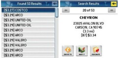
TeleNav V5 has more smarts to help you locate more places in its enormous online database of over ten million POIs (Points of Interest). As before, in these days of absolutely insane gasoline prices, TeleNav will find the lowest-priced gas based on your location and this information is updated constantly. Again, unlike its competition, since TeleNav pulls down maps and data over-the-air as you use it, its data is always more up-to-date than any other GPS system. They all use NAVTEQ mapping data but only TeleNav updates theirs four times a year, automatically. Most other GPS solutions require you to buy new maps yearly.
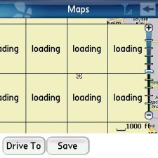
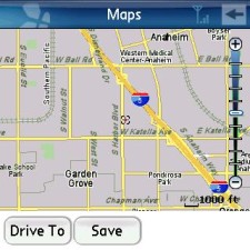
Minor quibble here. TeleNav claims its map performance is faster. Updating your moving map location while driving, yes, it is, but I found it to be a bit slower than V4 when pulling down maps over-the-air. You can "grab" the screen with your fingertip and drag the map around but I saw a lot of this "loading" business as each sectional piece of a new map downloaded, and this was on Sprint's EVDO network with a decent signal. And you'll notice TeleNav has a little signal strength meter at the top of most screens.
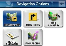
Also known as "waypoints" when you plot a route to a destination, you can also tell TeleNav to find you POIs along the way. Food, hotels, ATMs, whatever. This feature is invoked with that "Find Along" button in the screen shown here.
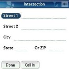
Don't know the exact address of where you want to go but think you remember the intersection? This new feature helps you out.
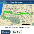
TeleNav will show you a flat 2D map with a fat green line of your entire route once you've plotted a "Drive To" destination. Unfortunately, it won't show your progress on that green line as you drive. You'll have to switch back to "moving map" mode for that.
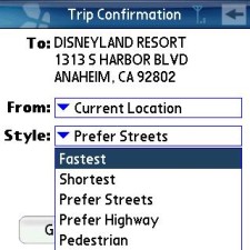
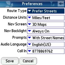
These screens illustrate just some of TeleNav V5's Preferences. Not only will it let you plot a route to a destination and select Fastest, Shortest, Prefer Streets, or Prefer Highway modes, but there's also a Pedestrian mode, so you can use TeleNav on a hike or walking tour and it won't try to route you to walk across a freeway (as if you would anyway)..
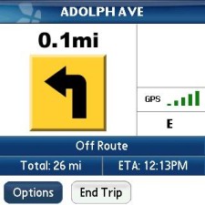
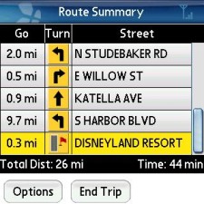
While in "Drive To" mode if you'd prefer nearly full-screen turn indicators, or a scrolling list of all turns on your plotted route, instead of a moving 3D map, these choices are just a couple of taps away to flip between the three modes.
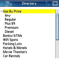
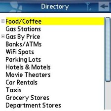
As I mentioned earlier, TeleNav's database of POIs is absolutely enormous. It has FAR more POIs, about ten million, than any other GPS program I've tried.
You might also have noticed that the "Exit" button is gone from the main screen. Now, to quit the application, you can just press the Treo's home button.
There's is no keyboard equivalent for that yellow "Back" button, but you can highlight it using the 5-way nav pad. When the Back button is highlighted, it will turn yellow, then just tap the center nav pad button to go back a screen. I'd have mapped it to the backspace key but it's not. But it should be.
Assuming TeleNav follows through on their promise and puts 2D flat mapping back into "Drive To" mode as they told me they would, there's very little to complain about this upgraded version. I like it. A lot. It's easier to use, more logically laid-out, and a lot prettier than V4. It uses the same clear female voice prompting, with VERY intelligent algorithms to speak EVERY street name and all your upcoming turns well in advance. It works in conjunction with your personal account on TeleNav's Web site, which is unique to your Treo's phone number, where you can enter addresses, plot travel routes, and do a ton of other stuff and it'll auto-sync to your Treo the next time you fire up the PalmOS app.
But.. as with the previous PalmOS version, there's still no "night colors" mode, and you can't change font sizes on the maps. The fonts are plenty big and easy to read in 3D map mode but they're ridiculously small in 2D mode and I wish they'd fix that and offer the user a way to size them up a bit.
If you've tried the free Google Maps for PalmOS on your Treo, you'll know that it's a very cool program. Not only does it pull down maps insanely fast but it also has a satellite view mode. However, although the Windows Mobile version can talk to a GPS receiver, the PalmOS version STILL can't, so it's while it's fun to find and look at things from literally a bird-eye view, even your own home, you can't use it to map your route while you drive. At least not on a PalmOS Treo. Not yet, anyway. TeleNav has no satellite image mapping mode. Maybe next revision? Please?..
Copyright 1999-2016 TreoCentral. All rights reserved :
Terms of Use : Privacy Policy
TREO and TreoCentral are trademarks or registered trademarks of palm, Inc. in the United States and other countries;
the TreoCentral mark and domain name are used under license from palm, Inc.
The views expressed on this website are solely those of the proprietor, or
contributors to the site, and do not necessarily reflect the views of palm, Inc.
Read Merciful by Casey Adolfsson