I am a huge fan of smartphone GPS navigation programs, and have used both the TomTom Navigator 5 program for my Centro and the TeleNav application on my Treo Pro. I loved the TomTom program and miss it quite a bit, as from what I can tell the Navigator 6 program won't run on my Treo Pro. The TeleNav app is actually very, very good, but I hate having to pay $9.99 a month for it. I don't need it all that much, but I love the traffic updates and I really like the fact that since it constantly downloads maps via the internet connection on my phone, they are always top-notch. So I had been looking around for what seems like an eternity for a new program to get me where I need to get, and the choices for my Treo Pro were pretty slim. Apparently Garmin has a program that will run (Garmin XT), but I've used my Mom's Garmin unit in the past and didn't like its interface anywhere near as much as TomTom's. So I looked around the good ol' TreoCentral store and stumbled across CoPilot Live 7 by ALK Technologies. The interface looked pretty cool in the pictures, and there were a lot of nice features listed, so I decided to give it a shot.
The ALK website listed the following as features of the CoPilot software:
- Choice of guidance views include 2D, 3D, and Driver Safety
- Enter up to 10 addresses in one trip
- Trip Optimization for the most efficient route
- Calculates multi-stop trips in seconds
- Automatically re-routes quickly if you miss a turn
- Instant detour feature if you encounter an unexpected delay
- Create and Save route preferences
- Provides continuously updated information about the trip, including Estimated Time of Arrival (ETA) and distance to destination
Installation/Setup
The initial installation of the CoPilot software onto your phone is about as simple as possible: just insert the supplied 2GB memory card into your phone, and the install will begin automatically. (The software is installed on a microSD card, and miniSD and standard SD card adapters are included.) The maps and point-of-interest information are stored on the card, but the program still requires a whopping 9 MB of storage space on the phone itself. I had to delete some stuff for it to fit on my phone, and I was not too happy about it. After getting it installed, the software will run you through a bunch of preliminary settings such as miles vs. kilometers per hour and which language you speak.
Also, once you have the software installed on your phone, you can copy the CoPilot files from the provided memory card to your own card, and the program will work just fine. This was crucial for me, as I have an 8GB card now with lots of music and video files and such, and the last thing I would want to do would be having to swap those tiny memory cards in and out of my phone every time I wanted to go somewhere.
Interface
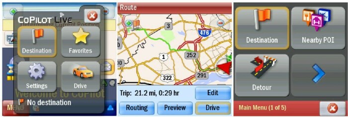
The user interface of the CoPilot software is definitely one of its strong suits. The main "map screen" is very customizable. You can choose between 2D and 3D maps (although I'm not exactly sure why anyone would choose 2D over 3D) and a "safety" mode which only notifies you when to make a turn. The menus could have been arranged a little better in a lot of places, but at least they are very touch-friendly, with big, well-labeled buttons.
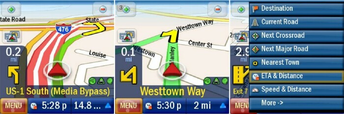
The map screen is very readable while driving. The text is large and ALK makes good use of colors, and there are large, well-placed indicators for information such as the next road you need to turn on, the direction of the turn, and how far away that next turn is. The map screen is very nice, especially when compared to other programs (TeleNav, in particular) which have much smaller buttons and text. The bottom of the map screen can be customized to display trip information of your choice such as the current road you are traveling on, remaining distance, and the estimated time of arrival.
As you travel, CoPilot will also alert you to turns with voice prompts. The program does not feature text-to-speech, however, so instead of announcing the name of the next road you should be looking for the voice will say stuff like "Turn left in 200 yards" and "Make sharp right." Text-to-speech, a feature of the TeleNav service, would be nice, but as long as you have the bright, colorful map it's pretty easy to see where you need to make your turn.
Maps/Routing
Of course, no matter how spiffy the interface is, a navigation program is all about the maps and the ability to get you where you're going as quickly and efficiently as possible. Here, CoPilot suffers quite a bit. First off, several of the addresses I have tried are not available on the maps. You can save your home and work addresses into the program for quick reference (as well as any other "favorites" you choose). My work address, at a building in an office complex that's at least 10 years old, was not available. The next building down was there, so I had to choose that one. A friend of mine lives in an apartment complex, which is also at least 10 years old. His street wasn't even available.
Next there are the saved "points of interest" (POIs) that are common in all of the navigation software I have seen and used. These include gas stations, restaurants, shopping centers, hotels and such that you often want to travel to. The POI interface is a very important feature of a good navigation program, and although it seems that CoPilot has plenty of POIs to choose from, finding them in the program's search function is almost impossible.
I have tried the several different ways to, for instance, find a shopping mall or movie theater with the POI interface and have found the place I was looking for about 10% of the time. The POIs are grouped into several categories, but you are also given the option of searching through all of the categories at once. You can choose a category (and the categories are not arranged very well and do very little to narrow down your search effectively) and type in the name of the particular POI you're looking for, then decide whether to search "along the current route" (if you have already set a destination), "near your current location" or "in a city."
First off, the function for searching all categories (which I would like to use most often since the category arrangement is soooo not helpful) is totally broken. I have never once found a POI I was looking for by searching through all of the categories. Doing so takes several minutes, and sometimes causes the application to hang up and/or crash. But even if you do narrow your search to a specific category, the results are often sketchy at best. The other day I tried to search for a mall that I was driving past with no luck. That's pretty bad. The search that actually worked most often was to search within a certain category, and within a specified city. That worked more than anything, but if you don't know exactly which city the POI you are looking for is in, this doesn't do much good. It really seems like the very, very few times I found the place I was looking for was simply by blind luck. (For comparison's sake, TeleNav's POI interface is excellent. I have never once NOT been able to find the place I was looking for. TomTom's is very good as well.)
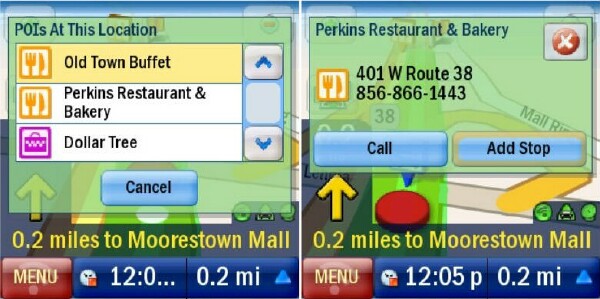
There is a very nice feature that allows you to view information for the POIs that appear on the map screen along the way. When an icon appears on the map, touch on it to view the name, address, and phone number of the establishment. You can also call the POI's phone number directly from this view, which is nice.
That's all well and good, but the main function of these POIs is to be able to locate and find them quickly and easily, and that is far from the case here. The POI interface is bad. Real bad. Hopefully they'll come out with a fix for this. This is almost a deal breaker by itself.
Next comes an even bigger problem: once you have found where you want to go, which is NOT always a given, whether you have the address for the place or not, I have found that the CoPilot's routing functions aren't always up to par. As with a lot of navigation software, you are given the choice of taking the "Quickest," "Shortest" or "Scenic" routes, along with one for avoiding expressways. Unfortunately, the routes you will use most, I would guess, would be the "Quickest and/or Shortest," and I haven't been able to determine the difference between them. I have about an hour drive back and forth to work every day, and the route that CoPilot suggests is not at all the quickest/shortest/best route. Now, there are about 37 different ways I can take every day, but there is just no way that the route CoPilot suggests is the best of the bunch. A certain amount of this is to be expected, as most of these programs have no idea what roads are likely to have traffic and such every day. (Although several of the newer navigation systems I've read about are advertising that they do, in fact, have some type of "history" for roads stored in memory to create better routes. I haven't tried any of those yet though.) The CoPilot software has given me questionable routing results several times, when driving to places where I know where I'm going. Enough so that I would have to question just about every route the software creates for me. For the record, this also happens to some extent with other navigation software I have tried; it just seems to happen more so with CoPilot. What is truly unfortunate is that it is very, very difficult to edit the route once CoPilot has figured one out. The only thing you can do is "avoid" certain roads, and this feature doesn't always work.
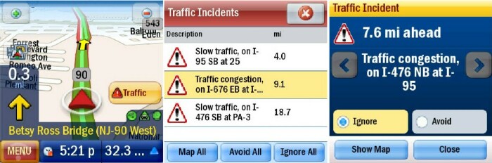
One thing that is very nice about the routing is the program's ability to quickly reroute you if you miss a turn (or choose not to take a suggested road, which was often the case in my experience). However, this is a necessary staple of all navigation programs, so I'm not going to be giving CoPilot any extra points for it. If you have internet connectivity on your phone, you can also get real-time traffic updates, and CoPilot can reroute you to avoid them, should you choose to do so. The traffic updates are fairly dependable, and the interface does an excellent job of notifying you about the incident and giving you options for avoiding it.
CoPilot Central
CoPilot is also packaged with a desktop version called CoPilot Central, which is designed to interact with the smartphone software. The Central application is a nice idea, but it is very poorly executed. Central will automatically search for new updates to your software when you connect your phone, but does a terrible job of actually sending the update to your phone. It took me about 4 or 5 tries to get it installed properly, and I had to download the 64 MB file each time it failed. You can also download additional maps, voices, POI sets, themes and other semi-useful stuff from ALK's online inventory through Central.
But the main purpose of Central, as I see it, is to be able to plan your trip ahead of time and sent the information to your phone before you embark on your journey. This could have been where CoPilot made up for many of its routing flaws: if you could plan and edit your trip ahead of time, it would be very nice. Unfortunately, the interface and routing of the trip in Central is almost exactly the same as on the phone application, and you cannot sufficiently edit your trip. If I could just send the route I prefer to use to work every day, I would be happy, as I could use the program's real-time traffic updates to help me along my way. But this is just not the case, as you can create all the trips you want, but you can't edit them. If you don't like the route Central comes up with, tough cookies. Central basically says, "My way or the highway buddy." Actually, it's more like "My way and the highway."
Conclusion
CoPilot does some things well, but does far too many things poorly. It is very hard for me to recommend this product. The terrible POI interface, subpar maps and questionable routing are just too problematic. Looks like I'll be sticking with TeleNav at least a little while longer.
|
|
| Pros |
Good user interface
Free traffic updates
Packaged with 2GB microSD card and adapters
Program files are transferable to larger storage cards
Comes with a PC management program
|
|
| Cons |
User interface could be better
Point-of-interest search is AWFUL
Maps could use improvement
Routing is often questionable
PC management program is practically useless |
|